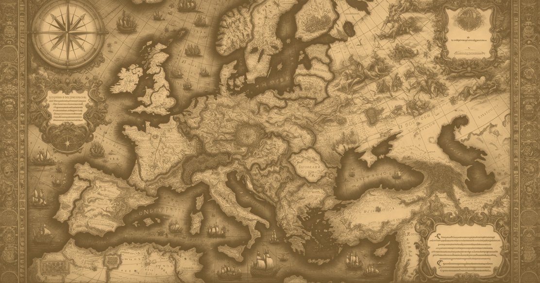
Map of Europe in the Renaissance: A Glimpse into Renaissance Cartography
In the Renaissance, maps played a pivotal role in shaping the way people perceived the world. These cartographic marvels were not merely tools for navigation but gateways to understanding the universe. This article delves into the profound significance of maps during the Renaissance period.
The Renaissance was an era of rebirth, and this spirit extended to cartography. The era witnessed a revolution in mapmaking, introducing innovations and rediscovering ancient knowledge. The maps of the Renaissance were both beautiful works of art and valuable sources of information.
Geography and maps were not just representations of physical landscapes; they were instruments of intellectual exploration. The quest for knowledge, driven by a desire to comprehend the world, had a profound impact on the Renaissance.

Characteristics of Renaissance Maps and Geography
The Renaissance era marked a pivotal period in the history of cartography, witnessing the emergence of skilled mapmakers whose works transcended the limitations of preceding centuries.
Visionary cartographers like Gerardus Mercator, Martin Waldseemüller, and Ptolemy became synonymous with the meticulous craft of mapmaking.
Pioneering Cartographers
Mercator, renowned for his cylindrical projection, revolutionized navigation charts, enabling more accurate representation of longitudes and latitudes.
Waldseemüller, in his 1507 map, introduced the term "America" in honor of Amerigo Vespucci, reshaping the world's understanding of the continents.
Ptolemy's ancient geography manuscripts were rediscovered, leading to their translation and incorporation into Renaissance maps, blending classical knowledge with contemporary exploration.
Materials and Techniques Used in Mapmaking
Renaissance cartographers embraced advancements in materials and techniques, departing from the medieval manuscript tradition.
Parchment, vellum, and paper replaced older materials, providing a smoother surface for detailed mapping. Copperplate engraving became a popular method, allowing for finer lines and intricate details.
These innovations facilitated the production of more aesthetically pleasing and durable maps, contributing to the widespread dissemination of geographical knowledge during the Renaissance.
Geographic Accuracy and Innovations
The Renaissance witnessed a concerted effort to improve the accuracy of maps, spurred by increased exploration and scientific curiosity. Cartographers endeavored to refine representations of coastlines, rivers, and mountain ranges, incorporating information from the latest voyages.
Innovations like the use of compass roses, scale bars, and latitude-longitude grids enhanced the usability of maps for navigation and exploration.
Despite some persistent inaccuracies, such as the elongation of certain landmasses, Renaissance maps laid the groundwork for the more precise cartography that would follow in subsequent centuries.
The Unique Geographical Context of Renaissance Europe
The geographical context of Renaissance Europe played a significant role in shaping the era's maps. The Age of Exploration prompted a surge in mapping activities as European powers sought to chart new territories and trade routes.
Maps became tools for political power, reflecting the competition among nations for colonial dominance. The portrayal of Europe as the center of the world, known as the T-O map, was prevalent, underscoring the Eurocentric perspective of the time.
The interplay between geographical knowledge, political ambitions, and cultural shifts during the Renaissance is evident in the rich tapestry of maps produced during this era.
The characteristics of Renaissance maps and geography showcase a transformative period in the evolution of cartography.
Pioneering cartographers, advanced materials and techniques, improved geographic accuracy, and the unique context of Renaissance Europe collectively shaped maps that not only reflected the state of knowledge at the time but also laid the groundwork for future exploration and mapmaking endeavors.
Purpose and Use of Renaissance Maps and Geography
One of the primary functions of Renaissance maps was to aid navigation and exploration, responding to the surge in maritime activities during this period. The accurate representation of coastlines, islands, and navigational features became crucial for sailors venturing into uncharted waters.
Maps, such as those by Gerardus Mercator, with his revolutionary cylindrical projection, provided mariners with more reliable tools for plotting courses and determining distances.
These navigational aids played a pivotal role in the Age of Exploration, facilitating daring voyages that expanded the known world and opened new trade routes.
Political and Cultural Significance of Renaissance Maps
Renaissance maps were not merely practical tools; they also held immense political and cultural significance. As European powers competed for colonial dominance and expanded their empires, maps became instruments of political power.
Lavishly adorned maps were commissioned by monarchs and nobility, showcasing territorial claims, conquests, and the wealth of newly discovered lands.
The use of allegorical imagery and embellishments on maps, such as sea monsters or exotic wildlife, reflected the cultural imagination of the time and contributed to the glorification of exploratory endeavors. Renaissance maps, therefore, served as visual representations of political aspirations and cultural identity.
Role in Shaping Renaissance Understanding of Europe
Maps of Renaissance Europe played a crucial role in shaping the way people perceived their own continent. The T-O map, depicting Europe as the center of the world with Asia and Africa on either side, was a prevalent representation during this era.
This Eurocentric perspective not only reflected a geographical understanding but also reinforced cultural and religious beliefs. Maps were employed to emphasize Europe's dominance and divine significance, often portraying the continent as the pinnacle of civilization.
These representations not only influenced public perception but also had a lasting impact on the way Europe positioned itself in relation to the rest of the world.
Renaissance maps served multifaceted purposes, from aiding navigation and exploration to becoming powerful tools for political and cultural expression. As Europe embarked on a new age of discovery, maps played a central role in shaping both the physical and conceptual landscapes of the time.
The intricate interplay between cartography, politics, and culture during the Renaissance laid the groundwork for the enduring influence of maps on human understanding and identity.

Notable Renaissance Mapmakers and Their Contributions
The Renaissance era witnessed the rise of visionary mapmakers whose contributions not only transformed the field of cartography but also left an indelible mark on the course of human history.
-
Gerardus Mercator (1512-1594): A Flemish cartographer, Mercator is celebrated for his groundbreaking cylindrical projection, which allowed for accurate representation of navigation charts. His work laid the foundation for modern mapmaking and navigation, making it easier to navigate longitudes and latitudes.
-
Martin Waldseemüller (1470-1520): A German cartographer, Waldseemüller gained fame for creating the 1507 map that introduced the term "America." This map was a landmark in the depiction of the New World, showcasing the newly discovered continents and significantly influencing European understanding of global geography.
-
Claudius Ptolemy (circa 100-170 AD, rediscovered in the Renaissance): Although not a Renaissance figure, Ptolemy's ancient Greek works on geography and cartography experienced a revival during this period. His manuscripts, particularly "Geographia," were translated and incorporated into Renaissance maps, merging classical knowledge with contemporary exploration.
Their Contributions to Mapping Europe
The contributions of Renaissance mapmakers extended beyond the mere representation of geographical features; they played a pivotal role in mapping and defining Europe during this transformative era.
-
Mercator's Projection and Nautical Charts: Gerardus Mercator's cylindrical projection revolutionized the accuracy of nautical charts, allowing sailors to navigate with greater precision. His projection method became essential for maritime navigation and contributed significantly to the understanding of European coastlines.
-
Waldseemüller's World Map: Martin Waldseemüller's 1507 world map, known as the "Universalis Cosmographia," marked a departure from earlier maps by introducing the name "America." This map provided a comprehensive and innovative representation of the known world at the time, including the recently discovered continents.
-
Ptolemaic Influence: The rediscovery of Ptolemy's works during the Renaissance had a profound impact on mapping Europe. Ptolemaic maps, based on mathematical calculations and astronomical observations, provided a systematic approach to cartography and influenced the layout of European territories on Renaissance maps.
Legacy and Influence on Modern Cartography
The legacy of Renaissance mapmakers endures in modern cartography, with their innovations continuing to shape the way we perceive and represent the world.
-
Mercator's Projection: Mercator's cylindrical projection remains a standard method in modern cartography, especially for navigation charts. Despite criticisms for distortion at high latitudes, the Mercator projection is still widely used for its practicality in sea navigation.
-
Geographic Knowledge Expansion: The contributions of Renaissance mapmakers expanded the known world, laying the groundwork for subsequent explorations and discoveries. Modern maps, built on this foundation, continue to reflect and expand upon the geographical insights of the Renaissance.
-
Cultural and Political Influence: The cultural and political significance embedded in Renaissance maps has left a lasting impact on the representation of territories. Modern maps often grapple with similar issues of cultural identity, political boundaries, and the nuanced interplay between geography and power.
The notable Renaissance mapmakers, including Mercator, Waldseemüller, and the resurgence of Ptolemaic knowledge, played instrumental roles in shaping the course of cartography.
Their contributions not only defined the geographical understanding of their time but also left an enduring legacy that continues to shape the maps we use today.
Preservation and Availability of Renaissance Maps
Preserving the delicate and often centuries-old Renaissance maps has been a challenging yet essential task to ensure that these invaluable artifacts continue to enlighten and inspire future generations.
-
Archival Conservation: Many institutions and libraries with significant map collections employ specialized conservation techniques. Archivists carefully store maps in controlled environments, protecting them from factors such as light, humidity, and temperature fluctuations that can cause deterioration.
-
Digitization Projects: To mitigate wear and tear on physical maps, numerous initiatives have focused on digitizing Renaissance maps. High-resolution scanning and imaging technologies allow for the creation of digital replicas, ensuring widespread access while preserving the original documents.
Accessibility of Renaissance Maps in Modern Times
Advancements in technology and a commitment to scholarly accessibility have significantly increased the availability of Renaissance maps to researchers, historians, and the general public.
-
Online Archives and Databases: Many institutions, such as libraries, museums, and universities, have made efforts to digitize their map collections. Online archives and databases provide virtual access to Renaissance maps, allowing users to explore these historical treasures from the comfort of their homes.
-
Open Access Initiatives: Some organizations support open-access initiatives, making digital reproductions of Renaissance maps freely available to the public. This democratization of access fosters a broader understanding of historical cartography and encourages collaborative research.
Prominent Museums and Collections Showcasing Renaissance Cartography
Several museums and collections around the world house impressive assortments of Renaissance maps, offering visitors an opportunity to experience the beauty and historical significance of these cartographic masterpieces.
-
The British Library (London, UK): The British Library boasts an extensive map collection, including rare and exquisite Renaissance maps. Visitors can explore maps that played a crucial role in shaping the understanding of the world during this transformative period.
-
Bibliothèque nationale de France (Paris, France): The National Library of France houses an exceptional collection of maps, some dating back to the Renaissance. These maps showcase the evolution of cartography and its cultural and political implications.
-
Library of Congress (Washington, D.C., USA): The Geography and Map Division of the Library of Congress is home to a vast collection of historical maps, including many from the Renaissance period. The library actively engages in digitization projects to make these treasures accessible to a global audience.
-
Vatican Museums (Vatican City): The Vatican Museums exhibit an array of historical maps, often reflecting the ecclesiastical perspective of Renaissance cartography. These maps provide insights into the intertwining of religious and geographical narratives.
The preservation and accessibility of Renaissance maps involve a delicate balance between conserving fragile originals and leveraging modern technologies to share their historical richness.
Efforts in archival conservation, digitization, and open access initiatives, coupled with the prominence of museums and collections worldwide, collectively contribute to ensuring that the legacy of Renaissance cartography remains both preserved and available for exploration in the digital age.

Sailing Away & Wrapping Up
The impact of Renaissance maps reverberates through the annals of cartography, European history, and the broader Renaissance era.
The contributions of key figures like Mercator and Waldseemüller, along with the fusion of classical and contemporary knowledge, set the stage for a more nuanced and accurate representation of the world.
Mercator's projection, in particular, remains a standard in modern cartography, attesting to the enduring legacy of Renaissance innovations.
In the realm of European history, Renaissance maps played a pivotal role in the Age of Exploration, influencing the course of colonial expansion and shaping geopolitical narratives.
These maps reflected the political ambitions of nations, showcasing claims to newly discovered territories and contributing to the construction of national identities.
Furthermore, the interplay between maps and the broader Renaissance era underscores the interconnectedness of knowledge, art, and exploration. Renaissance maps not only depicted geographical landscapes but also encapsulated the cultural and intellectual zeitgeist of the time.
The Eurocentric perspectives, allegorical embellishments, and meticulous details on these maps provide insights into the mindset of a society undergoing profound transformations.
Their Lasting Impact on Cartography, European History, and the Renaissance Era
Renaissance maps and geography are more than historical artifacts—they are portals into a period of intellectual ferment, exploration, and cultural rebirth.
Their lasting impact on cartography, European history, and the Renaissance era as a whole cements their status as both valuable historical documents and timeless works of art.
As we continue to explore and understand our world, the legacy of Renaissance maps remains an enduring testament to the enduring quest for knowledge that defined this remarkable period in human history.
